 KFLFRUIT7 - DW8234 in Fruit Cove,
Florida
KFLFRUIT7 - DW8234 in Fruit Cove,
Florida
 Real Time Weather Statistics from Executive Cove |
|
• East Central Florida Tropical Weather Page
• MonthlyWeather Review - Annual Summaries of North Atlantic Storms,1872-2011
• NWS Southern Region Tropical Web Page
• National Weather Service JETSTREAM - Online School for Weather-Tropical Weather


NHC Marine Forecasts & Analyses
Tropical Surface Analysis & NWS Unified Surface Analysis

See current wind, weather, ocean, and pollution conditions,
as forecast by supercomputers, on an interactive animated map.
Updated every three hours.
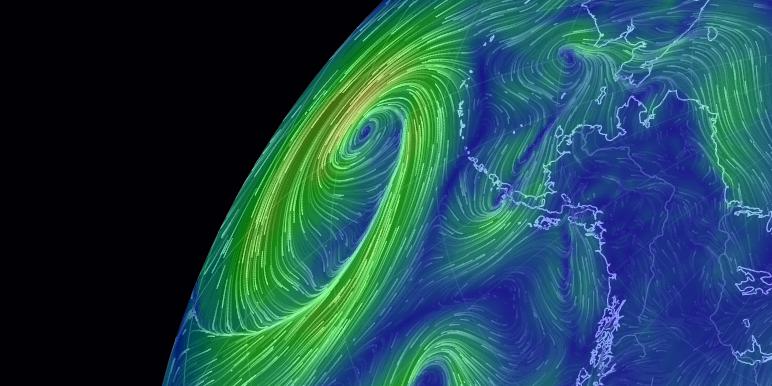
Earth Nullschool 81.39W & 30.10N
Earth Nullschool 49.76W & 20.65N
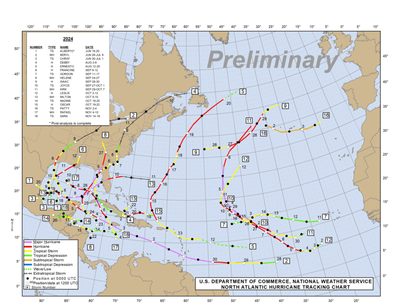
North Atlantic Tracking Chart
Preliminary for 2022
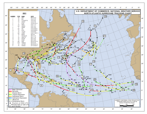
North Atlantic Tracking Chart
Final for 2021
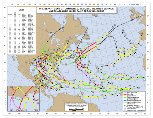
North Atlantic Tracking Chart
Final for 2020
North Atlantic Tracking Chart
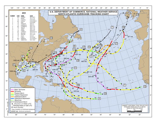
Final for 2019
North Atlantic Tracking Chart
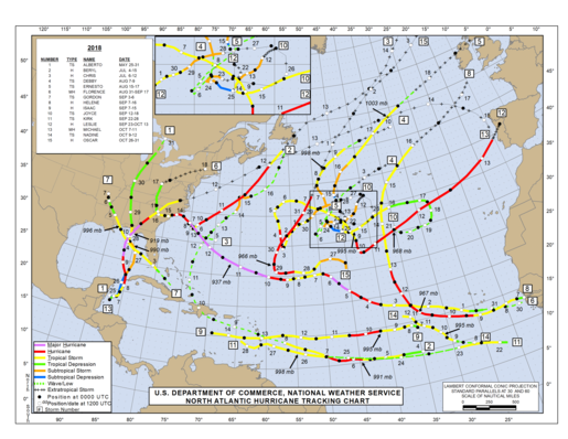
Final for 2018
North Atlantic Tracking Chart
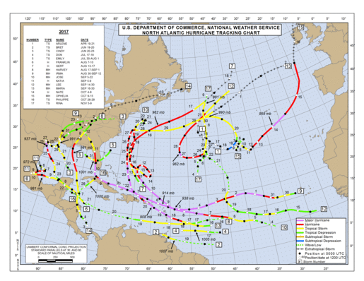
Final for 2017
North Atlantic Tracking Chart
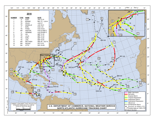
Final for 2016
|
GOES-East - Sector Views: Gulf of Mexico - GeoColor (Click on Satellite Picture for Loop)  |
GOES-East - Sector Views: Caribbean - GeoColor (Click on Satellite Picture for Loop)  |
|
|
Tropical Cyclone Imagery for the North Atlantic, Caribbean Sea and the Gulf of Mexico Atlantic and Eastern Pacific – SST Color Loop  |
GOES-16 East - Regional sector view: Tropical Atlantic - Wide View Band 13 10.3 um Clean Longwave Window - IR  |
|
 |
 |
 |
 |
 |
 |
 |
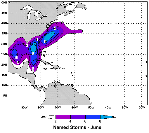
| Tropical Cyclone Probabilities - Named Storms in June |
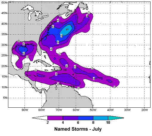
Tropical Cyclone Probabilities - Named Storms in July |
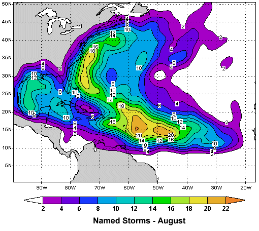
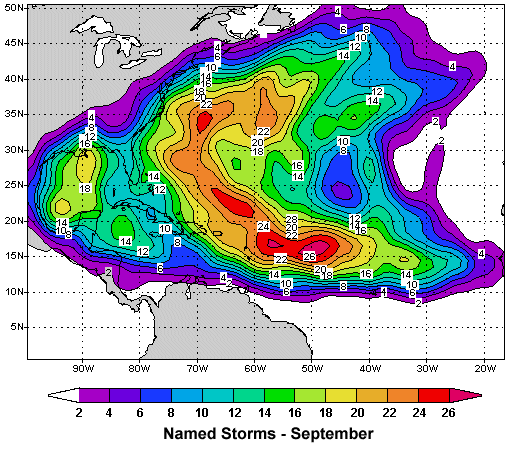
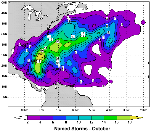
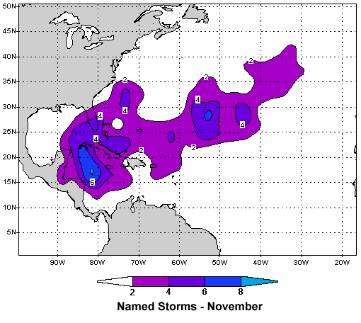
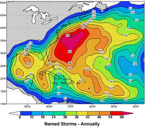
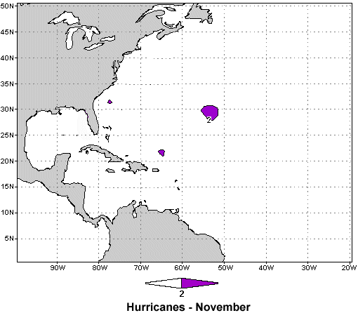
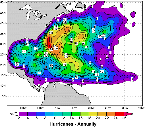
Tropical Cyclone Probabilities - Named Storms in August | Tropical Cyclone Probabilities - Named Storms in September | Tropical Cyclone Probabilities - Named Storms in October | Tropical Cyclone Probabilities - Named Storms in November | Tropical Cyclone Probabilities - Named Storms - Annually |
 |
 |
 |
 |
 |
 |
 |
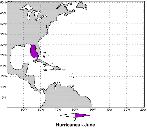
| Tropical Cyclone Probabilities - Hurricanes in June |
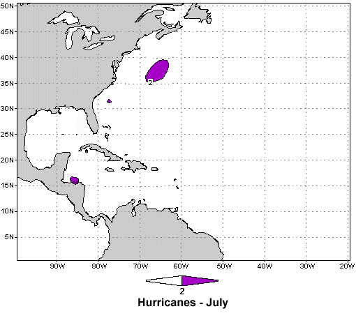
Tropical Cyclone Probabilities - Hurricanes in July |
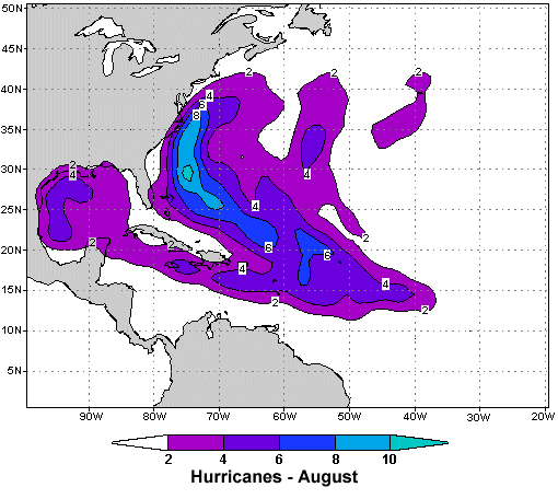
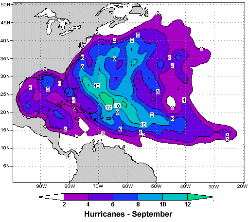
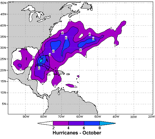
Tropical Cyclone Probabilities - Hurricanes in August | Tropical Cyclone Probabilities - Hurricanes in September | Tropical Cyclone Probabilities - Hurricanes in October | Tropical Cyclone Probabilities - Hurricanes in November | Tropical Cyclone Probabilities - Hurricanes - Annually |
 |
 |
 |
 |
 |
 |
 |
| GOES-East - Sector Views: Northeast U.S. GeoColor Image |
GOES-East - Sector Views: U.S. Atlantic Coast GeoColor Image |
GOES-East - Sector Views: Southeast GeoColor Image |
GOES-East - Sector Views: Gulf of Mexico GeoColor Image |
GOES-East - Sector Views: Tropical Atlantic - Wide View GeoColor Image |
GOES-East - Sector Views: Caribbean Sea GeoColor Image |
METEO SAT Eastern Atlantic AVN Color Image |
• NESDIS Tropical Cyclone Products
• NESDIS North Atlantic Tropical Products
• Tropical Cyclone Formation Probability Guidance Product - Atlantic Basin
GOES-East Full Disk View - GeoColor GeoColor - True Color daytime, multispectral IR at night
(Click on Satellite Picture for Loop)

GOES-East - Sector Views: Tropical Atlantic - Wide View - GeoColor
(Click on Satellite Picture for Loop)

• Sarahan Air Layer (SAL) Analysis
• CIMSS Realtime North Atlantic Satellite Images
• CIMSS Realtime Eastern Atlantic Satellite Images

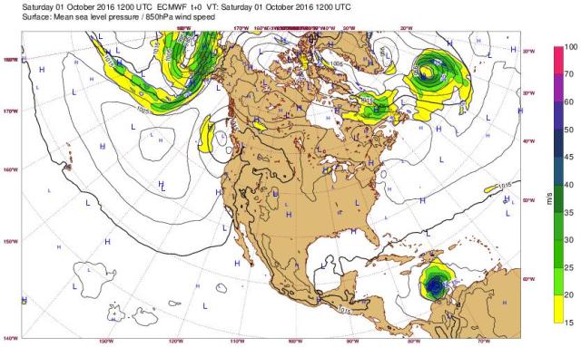
• European Centre for Medium-Range Weather Forecasts (ECMWF)
• Mean Sea Level Pressure and Wind Speed at 850 hPa North America (ECMWF)
• Mean Sea Level Pressure and Wind Speed at 850 hPa Central America (ECMWF)
• Mean Sea Level Pressure and Wind Speed at 850 hPa West Tropic (ECMWF)
NOTE: If when clicking on the ECMWF links above generates an initial Web Page with the following error:
"Failed to get chart packages"
or
"Product not found - Could not find the product medium-mslp-wind850"
or
"You are not logged in - Please note that many charts have restricted access."
simply click on REFRESH ↻ to bring up the current Web Page.
Early warning: The current ECMWF application will be retired soon, please consider using our new application.
For more information, please visit the first link below.
• Changes on Web Charts Application (ECMWF)
• Latest Tropical Cyclone Forecast (ECMWF)
• Tropical Cyclone Activity (ECMWF)
• Tropical cyclone activity (Including genesis) (ECMWF)
• FSU Tropical Cyclogenesis Model Output
• Penn State Tropical Cyclogenesis Model Output (Missing in action for a while now)
• Colorado State University - Tropical Meteorology Project Forecast Schedule
• NASA - NASA's Hurricane Web Page
• NASA - Specific Hurricanes in History
• Tropical Atlantic - Home Page
• Tropical Atlantic - Recon Page
On the Tropical Atlantic Recon Page go to the top center of the page and find the following:
MODELS:
To the right it may have several systems listed. The following is an example: Potential Tropical Cyclone Six
Select the system you want to explore & click on it. The next page that is displayed should have the
Models selection to the right of the map.
• Tropical Tidbits - Global Tropical Cyclone and Disturbance Information (Current Storms)
• Tropical Tidbits - Aircraft Reconnisance
• Tropical Tidbits - Satellite Imagery
• Tropical Tidbits - Numerical Model Prediction (Forecast Models)
• CPC - Climate Weather Linkage: Madden - Julian Oscillation
• Madden-Julian Oscillation: Recent Evolution, Current Status and Predictions
• Unisys Weather Hurricane-Tropical Data (No longer available)
New Items added on August 31, 2021 fall below this demarcation.
Zoom Earth shows live weather satellite images of the Earth in a fast, zoomable map.
Explore near real-time weather images, rainfall radar maps, and animated wind maps.
Track tropical cyclones, severe storms, wildfires, natural hazards and more.
• WINDY (also known as Windyty)
Windy is an extraordinary tool for weather forecast visualization that is a full color,
worldwide, animated weather map using GIS interface showing current and projected
wind and other weather conditions for any location in the world.
The data can be viewed at different spatial scales.
PowerOutage.US is an ongoing project created to track,
record, and aggregate power outages across the united states.
_Cropped_Final.jpg)
|
 |
|
Ambient Weather and
Weather Underground Never base important decisions on this or any weather information obtained from the Internet Portions of this Web Page are updated automatically by Virtual Weather Station V14.01 p43 Please note that some of the functionality of this WEB site depends upon the Weather Underground, KFLFRUIT7 Home KFLFRUIT7 Super Compass (Beta) KFLFRUIT7 Graphs and Gauges KFLFRUIT7 Daily Report KFLFRUIT7 Weather Details Forecast Weather-Area, Zone, Coastal & Surf NWS Radar and Forecast Offices Hazardous Weather Outlook Graphical Weather Links Weather WEB Sites Tropical Weather Page Archived Hurricane Radar Images Archived Hurricane Satellite Images Conversion Calculator Disclaimers Site Map * This page was last updated on Sunday, January 1, 2023 2:18:01 PM Copyright© 2011-2023: KFLFRUIT7 WEB Site designed and maintained by TVOR 
|